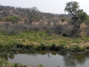
Mopanie Restcamp in the Kruger National Park
Mopanie Restcamp in the Kruger Park is one of a dozen Restcamps in the Kruger National Park. "Restcamps" are larger camps with shops, restaurants and offices. They normally also have other facilities like pools etc.
Mopanie is located next to the beautiful Pioneer Dam in the Tsendze river. The views over the dam from several of the huts as well as the restaurant/shop complex is amazing. It is surely one of the best places in Africa to enjoy a meal or a drink.
Mopani has several self catering accommodations, but no camping in the camp but at the nearby unique Tsendze Rustic Camp. Mopani Restcamp also features conference facilities.
Places to visit in the vicinity are the Stapelkop Dam, Mooiplaas picnic site, the Shipandane Overnight Hide and the Pioneer Dam hide, Hide, Thihongonyeni Waterhole and several others.
For game drives, walks, bush breakfast and bush braais, enquire at the Mopanie reception office when you book into the Camp.
For Sanparks online reservationsClick Here
We recommend the following trip to the immediate surroundings of Mopanie Camp.
Distance 109 km.
Drive Time without stop = 2 hrs 50 minutes
From Mopani, follow the H1-6 in a northerly direction and turn left into the gravel road towards the beautiful Shidlayengwenya waterhole in the Tsendze River. Spend a bit of time there under the large shady trees enjoying the peaceful bush atmosphere before going back to the H1-6 and left towards the Grysbok Waterhole and the S144.
Turn right into the S144, the Old Main Road, and stop at the Nwambu Waterhole on your right before turning right into the S143, the Tropic of Capricorn loop, towards the Thihongonyeni Waterhole where it is usually a good idea to spend some time watching out for elephants, buffaloes, some of the scarcer antelopes like Bastergemsbok and Roan. This waterhole always contributed to a good day's gameviewing for us
From here, further on to the junction with the S50, where you turn right to the N'Shawu waterholes on the left of the road. This area sometimes get very wet and one should be careful not to get stuck in the mud there. It is actually a large wetland and one normally finds a lot of animals here. That is, those you can see above the tall grass. There's also a lot of birdlife here, so take it slow and see what makes itself visible.
After the Nshawu's, turn right onto the H1-6 and drive to Mooiplaas Picnic spot. This piece of road runs on the bank of the Tsendze River and there's a good chance to see a wide variety of animals here. Turn left to Mooiplaas Picnic Site and try to get space at the lapa to the right on the riverside. There's a large group of Waterbuck who likes the place and several other animals like Kudu, Elephant, Crocodiles and sometimes the beautiful Saddle-billed Stork.
After Mooiplaas, turn left in the H1-6 and proceed towards the S142, but do make use of the loops to the riverbank, since these loops are sometimes very productive. Be careful for getting stuck in mud after rain here. If you take the last loop, it will bring you to a gravel road, the S142 which you must then follow to the left towards the Shipandane Overnight Hide where you may disembark to have a look at the animals and birds.
From Shipandane, take the S146 to the Stapelkop Dam. It is quite a distance to the dam, but we found it to be worthwhile every time, since the dam is normally well-stocked with animals and birds, while the road there and back also contribute some good animal sightings. A good last visit before returning to Mopani for a peaceful evening next to the fire and a good night's sleep.
In order to help people to get to know the Kruger Park better, we wrote a book containing large pictures, short descriptions, GPS Coordinates and travel times of more than 300 waypoints like camps, picnic spots, waterholes, dams, viewpoints and other interesting points along all of the public roads of the Kruger Park
The book is written in the form of a 20-day tour, taking the reader on a virtual tour through the park, giving the reader a rare graphical oversight over the park. Use the many GPS Coordinates to enjoy a pre-visit to the different places on Google Earth to make your virtual tour even more fun!
Although it is possible to follow the routes in 20 days, few people have the time available to travel all the routes described in the book, therefore it will be a good idea to download the book and do the virtual tour and then, after that experience, to design your visit to the Park as well as the trips and places you want to see and experience. .....read more"
CAMP REPORTS
TRIP REPORTS


